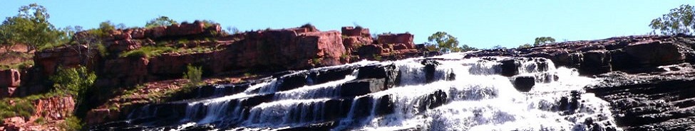
Mary River Wetlands – Overview & Things to See and Do
Overview
The wetlands region has an abundance of wildlife and is strongly influenced by the seasons. As a tourist destination it is has been well developed to complement and minimise environmental impact. Jumping Crocodile Cruises, Fogg Dam Conservation Reserve, Window on the Wetlands Visitors Centre and Wilderness Lodges are all within the 135km stretch along the highway from Darwin.
During the wet season dark clouds discharge enormous amounts of water in conjunction with amazing displays of thunder & lightning. The billabongs and lagoons link during this season to flood the surrounding plains.

Things to See and Do
Fogg Dam Conservation Reserve
The 1560-hectare Fogg Dam Conservation Reserve, is internationally recognised as one of the most populated biomass regions in the world. The wide variety of animal life, especially waterbirds are best seen early to mid-morning and mid to late afternoon. The most populated time of the year is towards the end of the dry Sept to Dec when the floodplains have receded.
The viewing platform is at the end of the road and is the best spot to view the area. There are also signposted boardwalks through the adjacent woodland and another leading into the lagoon itself. During the Dry, rangers lead night-time walks along the dam. You may prefer to explore on your own, but make sure you are equipped with insect repellant and a torch
Woodland to Waterlily Walk: Signs along this walk highlight the seasonal changes in a number of plant communities: woodlands, freshwater mangroves, paperbark forests and flooded plains. The walk is about 2 km in length. (Allow 45 minutes to complete – it is also accessible by wheelchair).
Monsoon Rainforest Walk: A signposted track and boardwalk takes you through patches of monsoon rainforest and paperbark swamp. The trail is approximately 3.6 km in length. (About 2 hours to complete – it is also accessible by wheelchair).
Night Walks: During the dry season, Ranger guided walks encourage visitors to experience the wide diversity of nocturnal wildlife found around the Dam. Don’t forget your tropical strength insect repellent.
Window on the Wetlands : An informative visitors centre with static and interactive displays presenting the environment balance that occurs in the wetlands. The interactive displays feature detailed information on various animal groups and on local Aboriginal and European history.
Window on the Wetlands is located on one of the highest points on the Adelaide River floodplain. So, from the top floor of the centre, you have uninterrupted views. In the wet season the wetlands are flooded and is an awesome site if you are there during one of the regions spectacular thunderstorms. Entry to the centre is free Opening hours are 7.30am – 7.30pm daily. Allow: 45mins
Adelaide River Jumping Crocs : A popular attraction that has been developed over a number of years. Through experience the crocs in the river know that when they hear the tourist boat is coming there is food available. The food is hung above the water requiring the Crocs to literally swim up out of the water to feed. It’s a fascinating thing to witness and it’s a natural ability crocodiles have. There is a coffee shop and souvenir shop.
Mary River National Park : Commonly overlooked as tourists focus on getting to Kakadu The National Park protects a part of the Mary River catchment area. Billabongs, lagoons, paperbark and monsoon forests provide opportunities for wildlife watching, fishing, bushwalking and photography.
A boat trip along this region is a highlight any time of year but to explore the floodplains during or after the wet is memorable. Dinghy hire is available at Shady Camp but unless you are experienced it is recommended you take a guided tour with a professional guide. Apart from the risk of crocodiles, orientation can become difficult when the wetlands are flooded.
Take note of the crocodile warning signs. Visitors must exercise extreme caution and common sense at all times in this area. It is strongly advised not to clean fish or discard fish carcasses along the water’s edge. It is not uncommon to see a croc every 100m sunning itself on the bank late in the dry.
Annabaroo Billabong : Directly south of the Bark Hut Inn on the Arnhem Highway, a track leads 2km to the Annabaroo Billabong, a collection of bush cabins and campsites including the original, century-old bark hut used by buffalo hunters. It’s a tranquil spot where you can swim and canoe in the billabong, and there’s also a small shop and a bar. Information on exploring the network of tracks south of the lake is available from the owners.
Brian Creek Monsoon Forest : Easily accessible detour just before the Wilderness Lodge turn off, this monsoon rainforest makes an interesting detour. This tropical jungle makes a strong contrast with the surrounding woodlands. Typical Time 1/2 hr
Bark Hut Inn : The inn is an unusual structure which houses an animal enclosure, restaurant, pub, pool, caravan park, fuel, eftpos, Art gallery and souvenir shop. Lots of character and a worthwhile stopover as a rest break or meal.
Couzens Lookout : Couzen’s Lookout offers exceptional views of the Mary River. It is only a short walk to the vantage point where the sunsets are stunning.
The Rockhole : A short walking distance from Couzens Lookout is another sightseeing platform, North Rockhole. This consists of a large pile of granite slabs protruding into the water which make a good vantage point. A boat ramp and picnic facilities are located here. Barramundi fishing is popular but be aware of the threat of crocodiles.
Mistake Creek : Mistake Creek Billabong, has excellent wet season observation vantage points. A viewing platform gives a shady spot to view life on the billabong.
Point Stuart Wilderness Lodge : Point Stuart Wilderness Lodge (08/8978 8914, fax 8978 8898; offers accommodation, a less expensive place to spend the night, with a pool, boat tours, gear rental and meals available with advance warning.
Point Stuart Coastal Reserve : If you arrive at Point Stuart you will be standing on the precise spot that John McDouall Stuart stood at the end of his journey across Australia in 1862.
The rough white sands are speckled by a myriad of tiny shells. Also scattered around are the twisted remains of dead trees that have been brought to land by sea. Due to the isolation of the area, apart from the ravages of a few passing cyclones, the land remains pristine.
Shady Camp : Designed to stop saltwater from penetrating further upstream, an artificial causeway barrage was built in 1987 at Shady Camp where fresh and salt water on the Mary River meet.
This casual meeting of fresh and saltwater produces some of the most memorable Barramundi fishing in northern Australia.
Here, the mullet converge to feed on algae washed down by a rushing stream of fresh water at the end of the Wet. Barramundi and other larger fish follow to feed on mullet. Shady Camp was named by John Stuart at the end of his epic journey. He named Shady Camp for the generous shade offered by trees. These days there is no shade whatsoever.
Wildmann River Lodge : A tidy bush camp around 15km off the Point Stuart Road with large tents or small air-con cabins and a nice bar/restaurant area with a pool. From here you can take a boat tour out to the Rock Hole
Near Wildmann Wilderness Lodge is Wildmann Lagoon, a stretch of clear water with blankets of blue, red and white lilies. An abundance of wildlife where little birds, hop gracefully from lily to lily and where crocodiles swim lazily.